
LiDAR Scanning a 100-Year-Old Railroad Bridge in Minneapolis, MN
Project Description
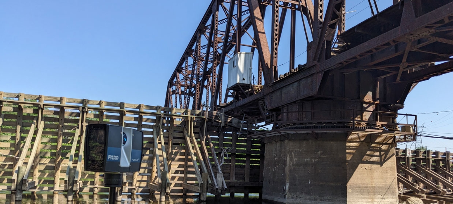
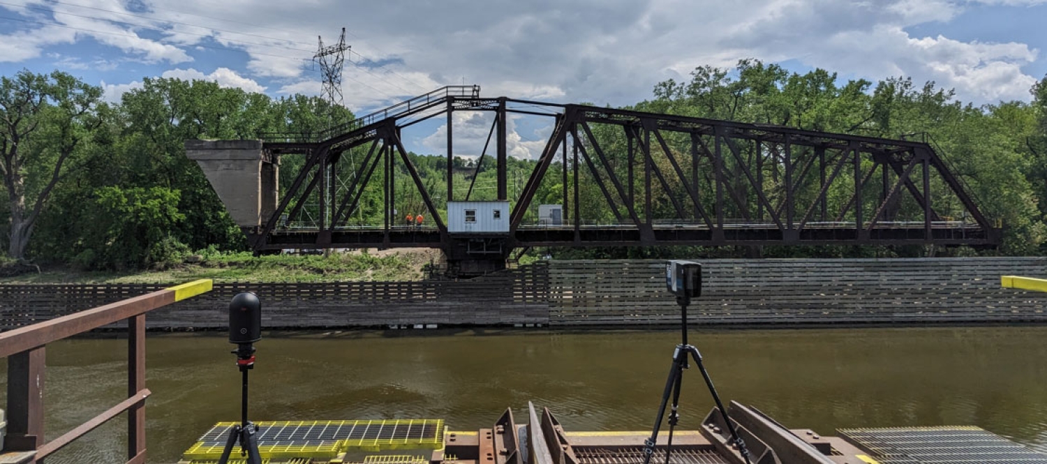
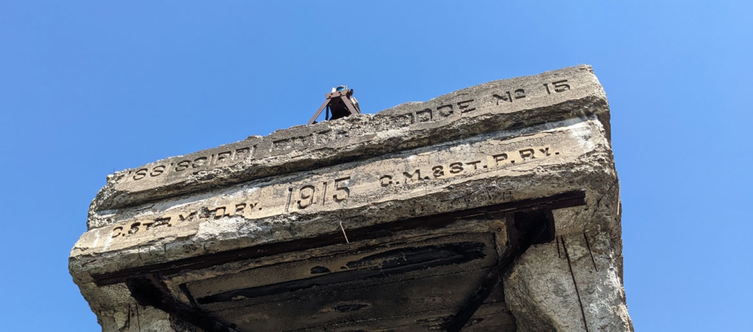
Historic infrastructure presents unique challenges when it comes to renovation, maintenance, and engineering documentation. Scan Skunks recently completed a specialized bridge LiDAR scanning project in Minneapolis, Minnesota, involving a century-old railroad bridge spanning the Mississippi River. The project required advanced planning, experienced field technicians, and a combination of long-range and portable laser scanning technology to accurately document one of the region's most significant transportation structures.
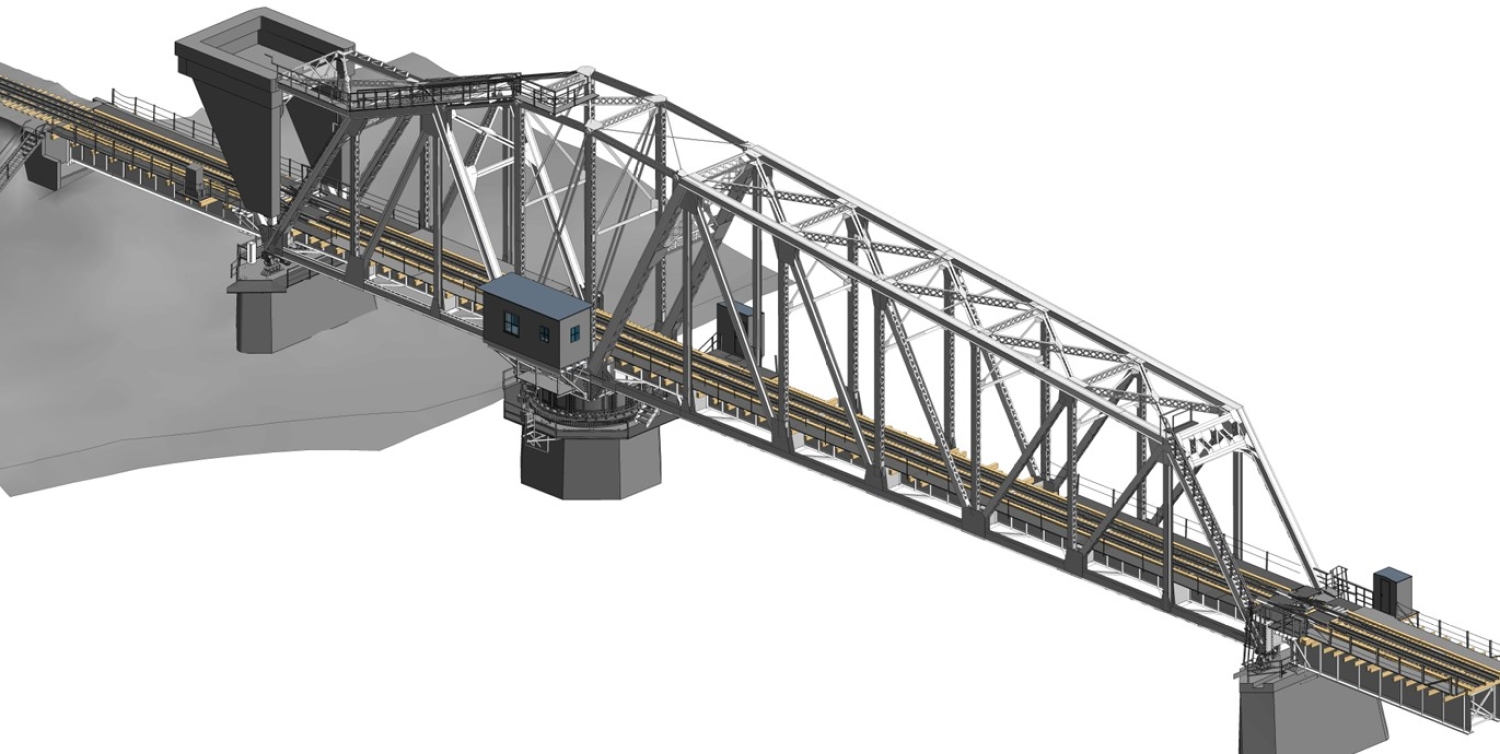
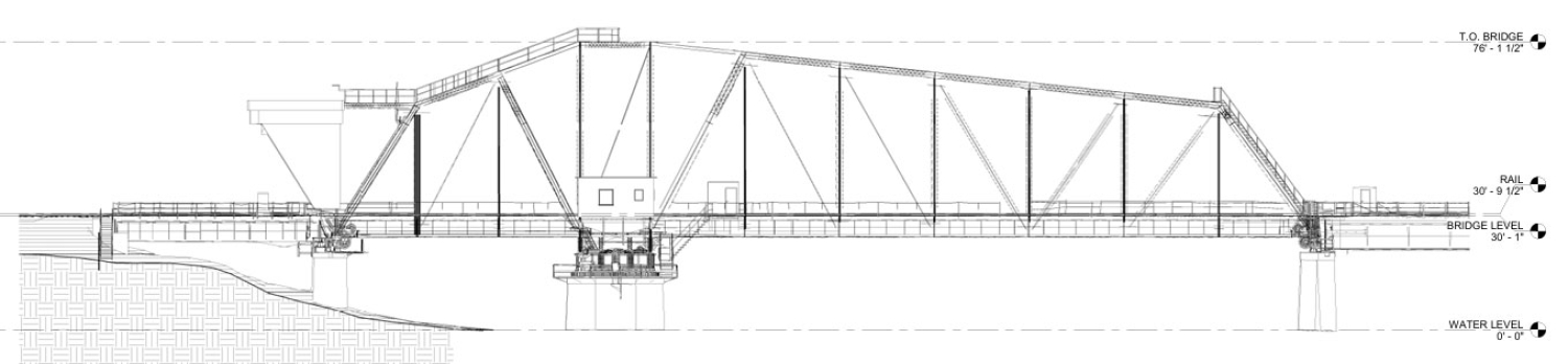
The bridge serves both rail and river traffic, creating a dynamic environment that demanded continuous coordination and on-site supervision throughout the scanning process. Despite the challenges, Scan Skunks successfully captured a complete digital representation of the bridge and delivered a highly detailed 3D model, including the complex mechanical gear systems housed within the bridge's rotating center section.
Documenting a Historic Railroad Bridge
Bridges that have been in operation for more than 100 years often contain unique construction methods, custom-fabricated components, and modifications that have accumulated over decades of service. Accurate documentation is essential when planning repairs, rehabilitation projects, structural assessments, or future modernization efforts.
For this Minneapolis bridge, the goal was to create a detailed 3D model that accurately represented the structure's geometry, mechanical systems, and operational components. Because many original drawings and records may no longer reflect current conditions, LiDAR scanning provided a reliable method of capturing existing conditions with exceptional detail.
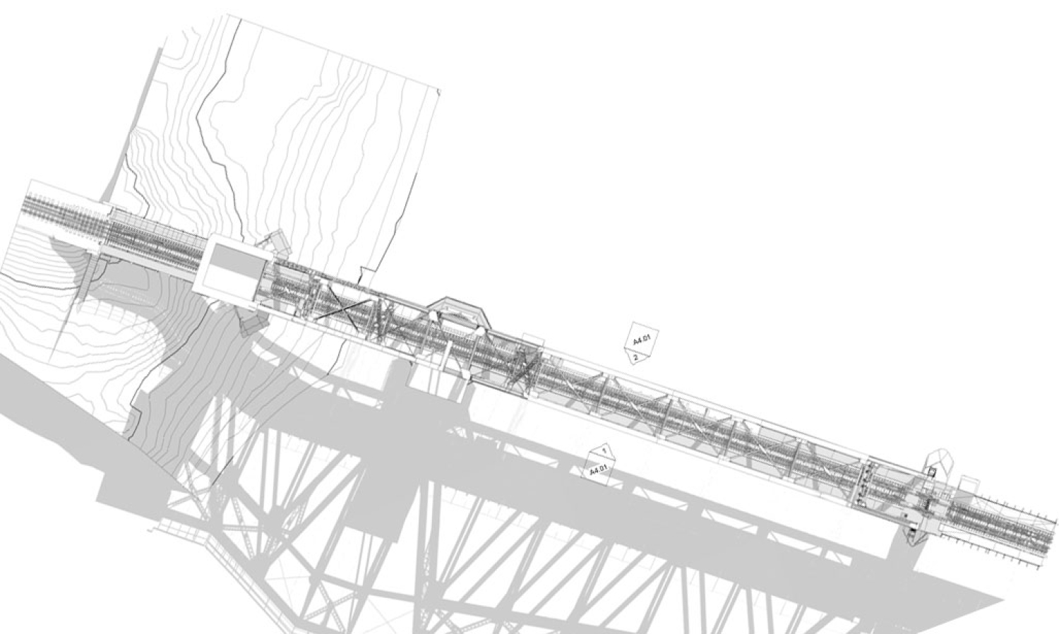
Using laser scanning technology, millions of measurement points were collected across the bridge structure, creating a comprehensive point cloud dataset that could later be used for engineering review, design coordination, and future project planning.
Utilizing Long-Range and Portable LiDAR Scanners
To efficiently capture the bridge within a single day, Scan Skunks deployed a combination of long-range and portable LiDAR scanners. Each scanner served a specific purpose throughout the project.
Long-range scanners were used to capture large portions of the bridge from strategic positions along the riverbanks and surrounding areas. These scanners allowed the team to collect accurate measurements across long distances while maintaining a high level of detail.
Portable scanners were utilized in areas where access was restricted or where additional detail was required. Their mobility allowed the team to document confined spaces, structural connections, and mechanical components that would have been difficult to capture using traditional survey methods alone.
By combining these technologies, Scan Skunks was able to create a complete digital representation of the bridge while maximizing efficiency during the one-day field effort.
The Challenge of a Working Bridge
Unlike many scanning projects where structures remain static throughout data collection, this bridge remained fully operational during the scan.
The railroad bridge serves both train traffic and river traffic, requiring the bridge to periodically open and close throughout the day. To accommodate passing vessels, the bridge rotates, allowing boats to safely navigate the Mississippi River. Once river traffic clears, the bridge must return to its operating position to allow train traffic to continue. This constant movement introduced a unique challenge for the scanning team. Data collection had to be carefully coordinated around bridge operations to ensure that the structure was captured accurately in its intended position.
Throughout the day, the bridge was repeatedly "seated" and "unseated" as train and boat traffic passed through. These operational changes required close communication with bridge personnel and project stakeholders. On-site supervision was essential to coordinate scanner locations, monitor bridge movement schedules, and ensure safe access for the scanning crew.
Successfully documenting an active transportation structure requires flexibility, experience, and a thorough understanding of both scanning technology and site logistics.
Capturing the Complex Gear Room
One of the most challenging portions of the project involved scanning the bridge's rotating center section, specifically the mechanical gear room responsible for bridge movement.
Located within the bridge structure, this area houses large gears, mechanical assemblies, and operational components that allow the bridge to rotate and accommodate river traffic. The confined nature of the space, combined with difficult access conditions, made this area particularly challenging to document.
Traditional measurement methods would have required significant time and effort to record the geometry of these mechanical systems. LiDAR scanning allowed Scan Skunks to capture every visible surface of the gear assemblies with a high level of detail.
Portable scanners proved invaluable within these confined spaces, allowing technicians to maneuver through the area while collecting dense point cloud data. Special attention was given to capturing the relationships between gears, support structures, shafts, and surrounding components.
The resulting dataset provided a comprehensive digital record of one of the bridge's most critical operational systems.
Importance of On-Site Supervision
Projects involving active infrastructure often require more than simply placing scanners throughout a site. Coordination, safety, and operational awareness become critical factors for success.
For this bridge project, on-site supervision ensured that scanning activities remained synchronized with bridge operations. The supervision team coordinated with bridge operators, monitored traffic schedules, and adjusted scanning workflows as conditions changed throughout the day.
Because portions of the bridge became temporarily inaccessible during opening and closing cycles, scanner placement and scan sequencing had to be continuously adapted. This level of oversight helped maximize productivity while maintaining safety for both the scanning crew and bridge personnel.
Delivering a Detailed 3D Bridge Model
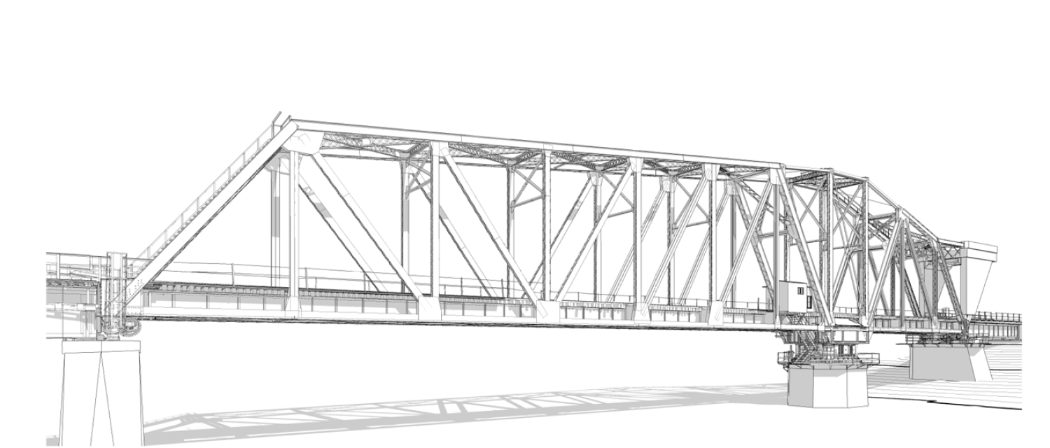
Following data collection, Scan Skunks processed the LiDAR scans into a unified point cloud and developed a detailed 3D model of the bridge. The final deliverable included the bridge structure, support components, mechanical systems, and the intricate gear assemblies located within the rotating center section.
The completed model provides engineers, architects, and facility managers with an accurate digital representation of existing conditions. This information can be utilized for rehabilitation planning, maintenance documentation, structural analysis, clash detection, and future design efforts.
For aging infrastructure assets such as this historic railroad bridge, having access to precise digital documentation helps reduce uncertainty and supports more informed decision-making throughout the project lifecycle.
Why LiDAR Scanning is Ideal for Historic Infrastructure
Historic bridges present numerous challenges that make traditional documentation methods difficult and time-consuming. Complex geometry, hard-to-reach areas, active operations, and aging construction methods all contribute to the need for accurate digital capture solutions.
LiDAR scanning provides a safe, efficient, and highly accurate method for documenting these structures without disrupting daily operations. By capturing millions of measurements in a relatively short period of time, scanning technology allows project teams to obtain comprehensive existing-condition data that would otherwise require extensive manual fieldwork.
For infrastructure owners and engineering firms working on bridge rehabilitation projects, detailed point clouds and 3D models provide valuable resources for planning, design, and long-term asset management.
Scan Skunks continues to support infrastructure, transportation, industrial, and architectural projects across the United States by delivering accurate LiDAR scanning, reality capture, and 3D modeling services for even the most challenging environments.